Breaking the Kodak: Surveillance and Subversion in the Monograph of the Republic of Haiti Map
Abstract
This article begins from the Monograph of Haiti Map project, which presents a set of aerial photographs taken during the U.S. military occupation of Haiti by mapping them onto contemporary satellite imagery using GIS. Reflecting on the process and methods of the project, I interrogate the operations of racializing surveillance and plantation visuality at work in both the aerial photos themselves and in the photomap as a digital object. I read occupation-era archives of photos, poetry, and sound through Simone Browne’s “dark sousveillance” and other paradigms to unearth traces of counter-surveillance and to understand contested Haitian spaces as dynamic sites of resistance to forced labor and racist extractivism. I take inspiration from Caco insurgents’ tactics of “undersight” to reflect on how this rendering self out of sight and other occupation-era freedom practices against racializing “oversight” might inform digital design choices for this project and others hoping to account for Black geographic knowledge.
I. Introduction
On the Monograph of Haiti Map, Haiti appears as a scattering of confetti pieces in a sea of white. Its silhouette is rendered in studded fragments, but those familiar with the country’s form will find its contours immediately and recognize the stars of the constellation as cities. Port-au-Prince is brighter, bigger; the outline of the Tiburon peninsula dotted with smaller sepia photos in regular intervals: Bainet, Côtes-de-Fer, Aquin, Saint Louis du Sud, and so on. The sprawling empty space around the cities seems to have resisted the photographer’s airborne lens. It remains opaque, unmapped, a receptacle for imagination.
These photographs were taken during the U.S. military occupation of Haiti and published in the 1932 Monograph of the Republic of Haiti. In keeping with 20th-century interventionist policies, the U.S. Marines had invaded Haiti in 1915, immediately declaring martial law under the pretext of maintaining political and economic stability in the country. A constabulary made up of Haitian troops raised and trained by U.S. Marines, the Gendarmerie d’Haïti, quickly became the key enforcing body of the occupation. For nineteen years, until 1934, the occupation’s field activities coupled aggressive corporate expansionism with Jim Crow-era white supremacist terrorism. Its agents perpetrated acts of economic and physical violence at every level of civilian society. These brutalities, including the civil conscription of peasant labor to build infrastructure, incited a series of anti-occupation revolts led by decentralized guerilla groups, or Cacos.1
The photos pinned to the satellite base layer on the Monograph of Haiti Map were originally collected as part of intelligence amassed by the Marines. Produced by the first United States Geological Survey aerial mapping project outside of the U.S., they illustrated the 900-page Monograph of the Republic of Haiti, whose object was “to provide operative and war plans information upon the Republic of Haiti.”2 The volume had been assembled to assist Marine officers in operating on the ground, and Marine Corps bases throughout Haiti housed copies for consultation. To convey intelligence information more clearly, the Monograph effectively dissects the country of Haiti into a list of towns in alphabetical order; each town’s section contains a photograph accompanied by scrupulous notes on population, agriculture, climate, topography, industry, and possible resistance activity. The report was held in the Marine Corps Archives in Quantico until 2014, when Duke’s Rubenstein Library acquired and digitized a copy.
I began digital work with the Monograph in the summer of 2020, in collaboration with Laurent Dubois, historian of Haiti, and Nicolas Scheffer, a graduate student in geography. Curious about what histories might emerge from reconfiguring the aerial photos, and especially hoping to piece together a diachronic environmental picture of Haiti, we decided to extract the images from their framework in the Monograph compilation and to lay them over a satellite base map. In the pages that follow, I focus on a set of theoretical and ethical questions brought to the surface by the mapping process.3 Without prescribing concrete formal modifications to the project, I employ Simone Browne’s concept of “dark sousveillance,”4 which provides a way to think through countersurveillance and the freedom practices generated against chattel slavery in order to probe how a critical theoretical reorientation inspired by these praxes might shape future iterations of the Monograph map and initiatives like it.
The incomplete mosaic image housed on the project website reflects strategic imperial objectives of nearly a century ago. It exists because of the use of aerial technology in the service of violent occupation—and because of our team’s work pulling photos from the binding of the U.S. Marines’ wartime compilation. The website’s base map gallery allows users to change the map format beneath the aerial photos to generate a picture of how road systems, urban areas, rural zones, and coastlines have transformed over the last near-century. The zoom tool’s shift of scale reveal the aerial photograph’s meticulous contours of roads, grids of city blocks, tree cover, and coastlines as they appeared in 1932. Waves, captured breaking onto a beach ninety years ago, are fixed mid-movement. This photo-object came into existence in the service of aggressive land-grabbing and corporate extractivism, fed by racist regimes of forced labor. The digital project gives it new life as a map.
The impetus behind the mapping project was to reanimate these images—photographs of towns with attached metadata of altitude, scale, and place name—by liberating them from their accompanying text in the Monograph and setting them against present-day satellite imagery. The team did this through georeferencing each image, and the process troubled and intrigued me.5 What did it mean to close the distance between sets of points across time, between captured space in one political moment and its future anchor on the earth’s surface? The practice of transforming these occupation-era snapshots into a map and effectively bringing 1932 to meet 2021 was not benign; the act of elevating reconnaissance photography into cartography seemed to endow these surveillance objects with more power, greater legitimacy.
As we attributed coordinates to the photos, I was reminded of Vincent Brown’s observation that “cartography presumes the natural existence of points on a grid much as history naturalizes the timeline, though these are ultimately folkways for representing space and time that have more in common with slaveholders’ epistemes than with those of their slaves.”6 Our mapping efforts were intended to be redemptive, to repurpose the images towards ends very different from those of occupation-era surveillance. But we were aware of the harm that might be done by naturalizing (and neutralizing) occupiers’ representations of Haiti’s inhabited landscapes. The term “georectification” has vague moral connotations, as if an image without coordinates on a spatial grid is a wrong that needs to be made right. The team felt there would be some value in making these images accessible in a digital cartographic format, though we struggled to make sense of the epistemological and ethical stakes involved in doing mapping work with this set of sources. On the other hand, if done a certain way, our appropriation of this part of the occupation’s photographic legacy might open possibilities for reassessing wider issues of representation, surveillance, geographic knowledge, sensory perception, and the afterlives of enslavers’ epistemes.
The photos, read against the satellite images of today, tell stories of changing landscapes and hold unmined secrets for researchers. There is dynamism in witnessing rivers cut new courses; there is energy in processes of erosion and urban expansion. It is sobering to visually perceive the rise of sea levels, disappearing tree cover, and soil runoff in lavalas (landslides/avalanches) over the last near century.7 The project directly illustrates the discourse of Anthropocene islands, visually endorsing arguments of engineered ecological vulnerability in the wake of colonialism and slavery. But there is eerie stillness and stasis in the landscapes emptied of meaning beyond the all-seeing gaze from above, both in 1932 and in 2021. Today, these pairs of images can be made to fit the too-easy, overdetermined script of environmental degradation exacerbated by nonsovereignty, by lamizè (misery/poverty).
How can a critical viewing experience not be tainted by frustration at the continuities between the world of these monochrome views and the world of today? Katherine McKittrick repeats, “description is not liberation.”8 Neither is representation. This article therefore takes the digital map as a catalyst for further reflection and thinking-with a set of scholars of Black geographies and surveillance, some of whose work appears in previous issues of archipelagos. Drawing on occupation-era Haitian archives, I endeavor to generate a dialogue with experiments in thinking beyond Cartesian grids, in racializing aerial gazes, and in the replication of these grids and gazes in digital form. Instead of reinforcing views from above, I enter, through the Monograph Map project, into explorations of nonvisual perception, Browne’s “dark sousveillance,” and other strategies for evading capture by aerial or frontal fixing gazes. By turning to Black diaspora theorists, I attempt to make room for Haitian understandings of space as an opening onto the urgent, wider conversation about digital equity and ethically responsible DH work involving Haiti.
II. “Overseeing,” the aerial gaze, and plantation visuality
If photography has been employed since its inception to create and catalog human difference, aerial photography has a distinct way of doing so. The Monograph’s photos, at first glance, do not act with the violent capture of those centering human subjects, such as the now-infamous 19th century photos of “human zoos” in World’s Fairs or Expositions universelles.9 The only photos of human subjects in the Monograph are of uniformed members of the Gendarmerie d’Haiti, the corps trained by U.S. Marines and “Haitianized” by 1932, with U.S. personnel being phased out and replaced by trained Haitian officers. The Monograph reports that these men conducted themselves “excellently” during the “Cacos Trouble,” presumably in putting down peasant unrest.
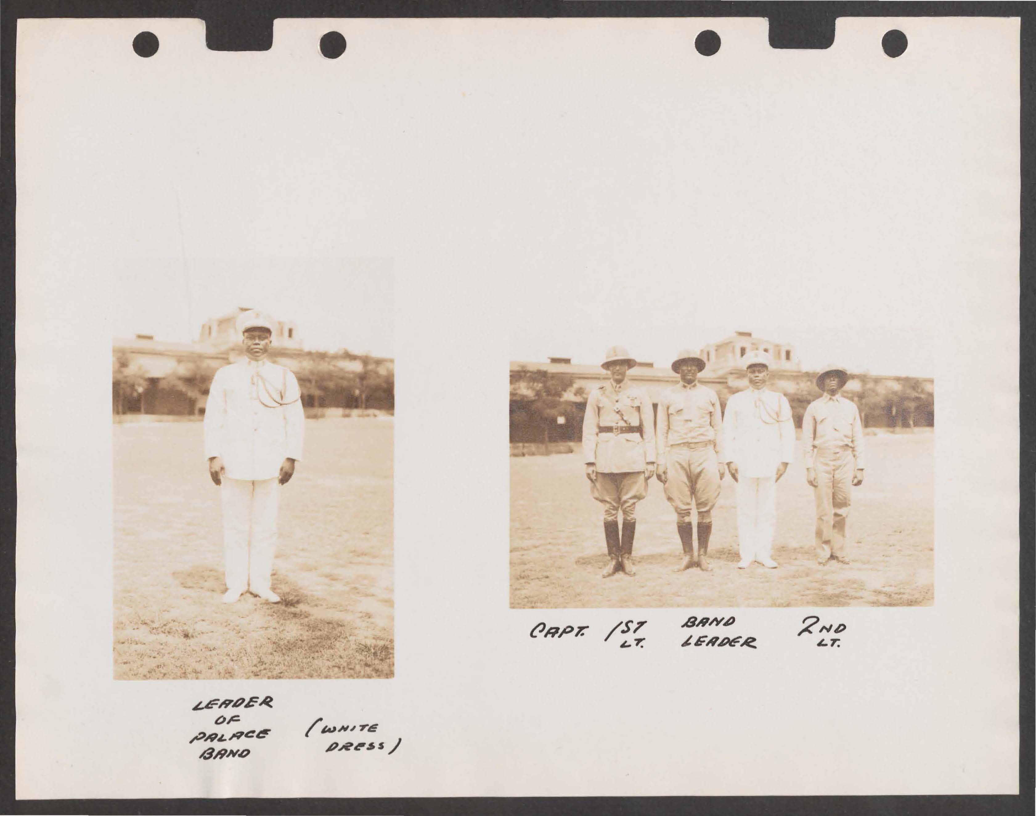
Monograph image of the Garde d’Haiti.
The Monograph’s aerial photos are not portraits cataloged by projects of biological racism; the violence and erasure they perform are of a different sort. Instead of a gaze that meets the camera, defiant or opaque, an invisible gaze behind the camera animates a visual operation that has its roots in that of the all-seeing agent of plantation goings-on. Aerial vision, or seeing from above, has semantic and genealogical resonances with what Nicholas Mirzoeff names as “oversight.” Oversight extends the “nomination of what was visible to the overseer on the plantation” to address the sensory primacy of the visual in the ordering of slavery and as a perceptual practice underpinning western epistemes in general.10 Plantation visuality operates through “a combination of violent enforcement and visualized surveillance” meant to manage time and labor to extract the biomass of cash crops.11
Although taken by an occupying force justified by white supremacy and racial capitalism, the sepia landscapes comprising the map are deceptively neutralized by their juxtaposition against open-source satellite imagery. But the Monograph’s aerial photos are in fact inscribed in the long practice, in American plantation zones, of siting/sighting relational, biodiverse ecological spaces into legible orders of racialization and extraction. In a very direct sense, during the U.S. occupation, companies like the Haitian American Sugar Company (HASCO) relied on inherited colonial tactics for spatializing plantation layouts and for managing time and labor to generate profits. As the latest technology of modernity in 1932, the marines’ airborne camera oversaw not only one plantation but the entire western half of Hispaniola; to extract labor and sugar from a whole country demanded a new sca[le of hyper-visual surveillance. The Monograph photos themselves embody traces left by this “plantation complex of visuality,” whose spatial logics continue to undergird forms of racialized surveillance.12 Furthermore, this visual power acts forcefully on mountains, plains, and seascapes, reducing complex sites of human-ecological engagements to birds’ eye objects of enclosure and possession, and exposing potential refuges.
In her reading of British colonial cartography in The Black Shoals, Tiffany Lethabo King calls attention to the “White cartographic subject,” or disembodied, over-represented Cartesian subject that writes itself into being by “spatially fixingand capturingforms of Black fugitivity and Indigenous resistance.”13 The Monograph’s aerial surveillance photos are a 20th-century iteration of a longstanding western imperial tradition in which mapping techniques act as symbolic arsenals that differentiate and solidify hierarchies of humanness through what they represent and how they represent it. From colonial cartography to aerial photography to mapping technologies used in this project, mobilized for racialized forms of policing and military surveillance, the construction of a dominant subject via views from above requires the denial of subjecthood of those observed. The overseeing geographic subject, agent of plantation visuality, creates itself by reifying its Others and their meaningful places as objects. As Katherine McKittrick succinctly contends, “past colonial encounters created material and imaginative geographies that reified global segregations through ‘damning’ the spaces long occupied by Man’s human others.”14
While handling the 1932 images, I was struck by these photos’ resemblance to their 18th Century counterparts, the intricate maps produced by colonial era cartographers in Saint-Domingue. Because these cartographers also focused on towns and plantation regions, their maps represent many of the areas depicted in the Monograph’s photos. On the 1785 ink-and-watercolor maps of the French marine engineer René Phelipeau, the features of Saint-Domingue towns are rendered with martial accuracy, reifying colonial imaginaries via colorful representations of physical markers. Possessors of plantation properties come into being as geographic subjects as the boundaries of their habitations (plantations) are traced and marked with their family names. At the same time, Phelipeau’s maps attempt to reveal and render legible forms of Black fugitivity, labeling sites of refuge such as mornes (mountains).

Phelipeau, “Plan de la Baye et du Bourg de Tiburon dans l’Isle St Domingue,” 1785. From the Memoire des Hommes database hosted by the Service Historique de la Défense, Paris
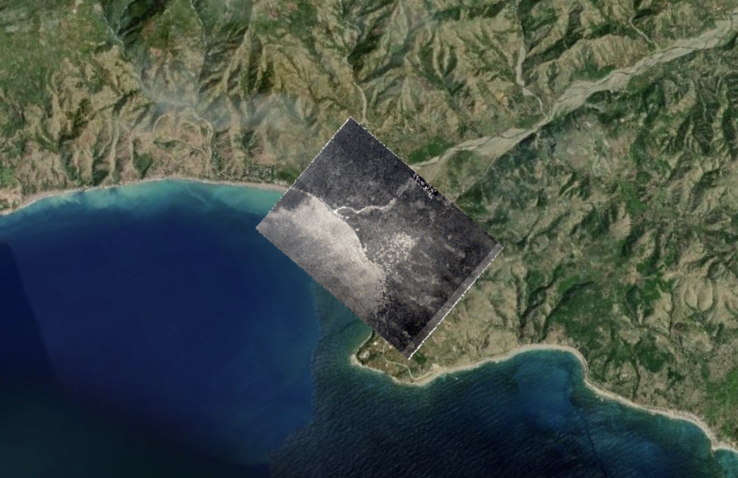
Screenshot from the Monograph of Haiti Map, 1932/2022.
In the case of the Monograph, its photos were key to a strategic and comprehensive compiling of information from spaces occupied by Man’s human others. They were essential in a project that sought to deploy the discipline of geography for capitalist extraction by concurrently making war on Haitian peasants and their sovereign land management practices, “damning” spaces inhabited by both visible and invisible forms of life. Recognizing aerial technology and its totalizing ambitions as conceptually beholden to European colonial cartography brings to light the close links between epistemic and physical dispossession. The knowledges produced by colonial and occupation administrations worked to negate earth-based ties to ancestors, articulated through the lakou system of land ownership common in rural Haiti,15 and to transmute layered, spiritually meaningful ecologies into extractable resources. Concretely, persisting colonial geographic imaginaries had/have their material expression in the accumulation of land and capital. The occupation, backed by its comprehensive aerial gaze, resulted in the emptying of the Haitian national bank, the rewriting of the Haitian constitution in 1918 to allow foreigners to purchase land (outlawed since independence), and the subsequent acquisition of tens of thousands of acres by American corporations.
The Monograph artifact itself, presented as an exhaustive, encyclopedic register of knowledge containing “all the information obtainable to commence active operations” in Haiti, clearly discloses the imbrication of racial subjugation with certain modes of geographical legibility.16 The corvée, or shackling of rural cultivators for unfree work in infrastructure,17 created roads and access to Haiti’s interior. Occupiers’ strategies for rendering the landscape transparent and accessible, such as road building and aerial photography, led to the exposure of Caco hideouts and massacres of peasants. The planes that took photos also dropped bombs on civilian populations; Thomazeau and Les Cayes were attacked from the air in 1919. In the photo of the latter town, there are visible empty spaces along the streets, conceivably left by the bombing a few decades earlier.
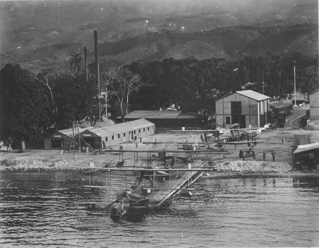
U.S. Navy Curtiss HS-2Ls and other airplanes in Haiti circa 1919.From the Walter V. Brown Collection (COLL/4326), Marine Corps Archives & Special Collections.
III. Detours into dark sousveillance
During the hours spent scanning for stable points in flattened, emptied landscapes, I wondered who had been removed, what practices and everyday paths of living made invisible, what knowledge erased. As I inscribed a new layer of legibility onto the photos through georeferencing, I thought about resistant forms and configurations of life, and about the embodied refusal of occupying forces.
The creation of the white geographic/cartographic subject in tandem with overseeing relies upon the notion of transparency and the creation of transparent space, where making transparent can be understood as violating Glissant’s right to opacity.18 In the contexts of slavery and post-slavery, a consistent goal and method of oppressors was to capture the other through total comprehension. Pushing up against this violent drive towards transparency, then, many scholars identify Black geographic knowledge and placemaking as (not exclusively, but significantly) informed by fugitivity and furtivity; uncontainability and excess; invisibility and fungibility.19
Simone Browne locates the birth of contemporary racializing surveillance in the practices of transatlantic slavery. She troubles a surveillance studies preoccupied with western modernity and notions like Foucault’s panopticon with readings of the slave ship, branding, slave passes and patrols, and lantern laws as surveillance mechanisms based on epidermalization. Most importantly, Browne recasts “sousveillance”— the antithesis of surveillance-as-oversight, from the French sur-, “from above” and -veillance, “watching”— to generate the concept of “dark sousveillance”:
I use the term ‘dark sousveillance’ as a way to situate the tactics employed to render one’s self out of sight, and strategies used in the flight to freedom from slavery as necessarily ones of undersight …I plot dark sousveillance as an imaginative place from which to mobilize a critique of racializing surveillance, a critique that takes form in antisurveillance, countersurveillance, and other freedom practices.20
Dark sousveillance is an active inversion of those power relations grounded in antiblack oversight and overseeing (“sur-veillance,” plantation visuality, and viewing from above) through acts of undersight, or appropriating, co-opting, and challenging “tools of social control in plantation surveillance …in order to facilitate survival and escape.”21 Browne finds these attempts to render one’s self out of sight in acts of physical fugitivity but also in the spaces of epistemic refuge generated by Black performative and spiritual acts and creative freedom practices—spirituals, songs, and dancing. What acts of dark sousveillance did resistance groups undertake against the racializing surveillance epitomized in the Monograph’s aerial photos? How is the existence of oppositional, countersurveillance imaginaries betrayed by the Monograph’s admission that “many inhabitants took to the hills rather than to submit to ‘corvee’ unjustly enforced”?22 How do traces of occupation-era attempts to render self out of sight necessarily prompt more nuanced approaches to the photomap?
Although by 1932 the U.S.-trained gendarmerie had suppressed most peasant resistance to the occupation’s expropriation of land and forced labor, earlier freedom efforts by Caco rebels haunt the pages of the Monograph. The anxiety provoked by these uprisings is reflected in the attention given to “Bandit Areas” as subheadings in descriptions of regional military departments. For example, in the Department of the Center, rural sections of Coupe Mardi Gras and Riviere Canot (Mirebalais) “appear to offer nests where bandits can hide” in the Department of the West, “the whole chain to the northwest, and the Montagnes Noires are places best suited to the free display of bandit activities.”23
The Monograph’s language citing spaces of Caco refuge as bandit “nests” manifestly reflects the Marines’ animalization of rebel fighters, but perhaps inadvertently echoes more sympathetic perceptions and/or mythic understandings of the Cacos’ political project. The insurgents who held out against occupying forces in the mountainous regions of Haiti share their name with a bird endemic to the region—either the red-plumed Hispaniolan trogon (Priotelus roseigaster), Haiti’s national bird, or, according to Haitian historian Pauleus Sannon, the “Tacco d’Hispaniola,” the Hispaniolan lizard cuckoo (Coccyzus lognirostris).24 Both are forest-dependent bird species that forage in dense vegetation and nest in tree cavities. Sannon writes that peasant guerillas used to hide, like their avian namesake, under plant matter to surprise and attack their adversaries. “Devenus par corruption Cacos, le sobriquet de Tacos fut donné aux insurgés, parce qu’ils se cachaient, comme l’oiseau de ce nom, sous la feuillée pour surprendre et attaquer l’ennemi.”25
Whatever species they were named for, the Cacos’ sobriquet stems directly from their identification with acts of dark sousveillance. Their work of placemaking and defense, adapted to contest capture and death from above, relied on a tactical use of foliage, topography, and the mirroring of animal movements to sustain survival and escape. Resistance fighters performed countersurveillance through camouflage and ambush techniques drawn from mountain ecologies, including rendering themselves out of sight under leaves and undersight-based surprise attacks. Cacos’ subversive geographic imaginaries, embodied in practices of dark sousveillance, were inspired by the natural world and by beyond-human ways of living. However, ultimately, the plantation visuality made possible by aerial technology undermined the success of these strategies:
Te U.S. opened the year 1920 with a concerted effort to rid Haiti of the insurgent war that had torn it apart for nearly two years. For the next six months, the improved force of marines and gendarmes relentlessly drove the cacos back whenever they met. The marines were assisted by the innovation of coordinated air-ground attacks through the use of two airplanes, a Jenny and a De Havilland.26
Yet another instance of the use of photography as a technology of terror—and its diversion by imaginaries of dark sousveillance—can be situated in the aftermath of the Cacos’ 1919 attack on Port au Prince, led by Charlemagne Peralte.27 After his betrayal and assassination, Peralte’s body was tied to a door and left to decompose on public display in Le Cap; copies of a photo taken by a U.S. Marine photographer were distributed in the countryside with the intent of discouraging resistance.28 But this visual multiplication of hypervisible, spectacular death—a dissemination of terror meant to surveil, control, and curtail Black life—did not have its intended effect. Photography as an instrument of oversight (not for traditional plantation surveillance, but to maintain the occupation and its racist, extractive regime of terror) was coopted, repurposed, challenged, and transformed, as “istead the photograph became an iconic depiction of Peralte as a martyr for liberty.”29 The photo of Peralte’s body, produced and circulated by the occupying overseers, signified differently to the peasant population, which turned this visual tool of social control against itself in an act of creative dark sousveillance. Peralte’s execution, its resemblance to a crucifixion, and his martyrdom and its subsequent iconography perhaps communicated symbolic undercurrents of resurrection and transformation. The door signifies as a cross; the cross suggests crossroads; the crossroads opens onto powerful, invisible forces.
Finally, in the wake of the occupation, the plantation complex of visuality-turned-tourist gaze meets stubborn resistance in Félix Morisseau Leroy’s 1953 poem “Touris, pa pran pòtre m.”30 The photographer’s entitled expectation of transparency is disputed by the subtle, hostile dignity and vocal refusal of Morisseau Leroy’s speaker: “pa pran pòtre m.”31 This rendering of self out of sight manifests through words of warning, with a threat of resistance powerful enough to break the Kodak camera, tool of surveillance and of potential epidermalization: “Kodak ou a va kase.”32 The American camera in the air, which Morisseau Leroy might describe as Kodak nan syèl la, saw and captured entire towns, rows of houses; it effaced their inhabitants, froze unruly vegetation and tumbling rivers. Yet the speaker cautions the American tourist:
Touris, pa pran pòtre kay la
Kay mwen, se kay pay
Pa pran pòtre joupa ajoupam
Joupa m, se kay tè
Pa pran pòtre jaden m33
The speaker’s insistent use of possessive pronouns works to repossess home and garden spaces in all their materiality, to wrest them away from and speak back against white visual power in an act of dark sousveillance. The admonition in this poem, its refusal of transparency and assertion of presence in the landscape, resounds against the emptied aerial photos of the Monograph Map. Taking seriously a perspective of undersight against oversight means respatializing the houses, huts, and gardens of the surveillance photos as belonging to someone, as opaque and resistant to views from above despite repeated aerial assaults.
IV. Openings beyond ocularcentrism
The current version of the Monograph Map project encourages the site’s visitors to think through the questions I have raised here. When users arrive at the home page, they do not immediately encounter the satellite base layers; instead, a certain disorientation is produced through the foregrounding of the white space around the incomplete mosaic of towns. A set of reflections and questions on the “About” page suggests further reading and invites visitors to do speculative, imaginative work looking for what else must have been happening in the landscape. Admittedly, these partial efforts fall short of tackling the deeper questions raised by framing the photographs as we currently do. In my conclusion to this article, I attempt to make a fruitful link between the freedom practices of Haitian dark sousveillance discussed earlier and the design approaches and tactics we might utilize in future versions of the project. Such countermapping would consider those who refused the U.S. Marine occupation as authors of their own geographies and would insist that their forms of representing and inhabiting space inform ways of seeing Haiti in the present.
Scholars employing digital mapping practices to represent and understand Black Atlantic history from below have long confronted the challenge of how to approximate, via design choices, ways of perceiving that refuse plantation visuality.34 Jessica Marie Johnson’s notion of Black digital practice “makes space ...for black diasporic longing, insurgence, hauntings, and community mourning to inform how digital tools might be used to uncover acts of resistance, insurgent politics, and evidence of self-fashioning.”35 The lens of Black digital practice encourages us to see past the obscuring tendencies of archives of structural violence and the supposed neutrality of the digital towards the experiential and embodied possibilities generated by Black geographic subjects. It helps us to ask how we might recognize or appreciate acts of dark sousveillance such as those of the Cacos’ camouflage or Morisseau Leroy’s speaker’s refusal to be photographed.
Can projects like the Monograph of Haiti Map be complemented or enriched to ethically chart praxes of living and “evidence of self-fashioning” beyond plantation and occupation oversight? How might we engage archives and digital methods to honor perspectives of the resistant overseen, instead of mimicking overseers’ gazes? Following McKittrick, in what ways might we attend to the connections between material spaces, language, and subjectivity, to explore the possibility of representing “an interpretive alterable world, rather than a transparent and knowable world”?36 Without abandoning the Monograph’s photos, is there room to express “dfferential modes of survival”—ways of perceiving, communicating, expressing, and being in the world?37
At its base, this is a question of how we envision users interacting with these maps. Placed over contemporary satellite imagery of Haiti, are they sufficiently transformed so that they can now be used to ends very different than those for which they were created? Can the photographs help us better understand how Haitians organized and lived in their space? Or is the form itself so imbued with the intent of surveillance that, in a sense, it can’t be redeemed from that original intent? Do we need a more prescriptive set of designs to make sure users move towards conceptualizing the inhabited landscape along different lines and through different terms?
A partial solution, in my opinion, is to strive for an equilibrium in design decisions that would allow for engagement with the photographs while recalling their part in the continuation of regimes of plantation visuality. Taken even further, this design would acknowledge the practices of dark sousveillance that resist the photos’ very existence, augmenting the project by interweaving or punctuating the photomap with archival materials that open onto perspectives of undersight, counter-visuality and opacity/counter-transparency. For this, we might turn to sources produced by ostensibly less extractive relationships to Haitian people and landscapes—fictions or ethnographies written during or about the period, for instance.38
Other Black Atlantic digital projects, including pioneering efforts in visualizing rebel war strategy and the flight patterns of maroons, have experimented with designs to exploit the possibilities of historical contingencies, uncertainties, and nonlinear temporalities, thus upsetting overdetermined historiographies of Black expendability and death. Scholars like Tao Leigh Goffe have asked what emancipatory potential lies in ways of navigating and perceiving beyond the visual realm, in collaborative intimacy with the beyond-human.39 Like the Cacos, Maroons absorbed beyond-human sensory epistemologies (in this case, bats’ echolocation), and their embodied expertise nurtured unique geographic imaginaries.
Haiti, since its days as Saint-Domingue, has been the scene of disrupting “ocularcentric forms of knowledge production and the written word,” a space of unmapping and countermapping through radical, ancestrally-grounded sensory orientations in space and time.40 Communal forms of inhabiting space like lakou and kombit41 and their urban and diasporic transformations imbue natural features, architectures, songs, healing plants, and subsistence agriculture with myriad and layered ties to invisible worlds. Haiti is home to “a decolonial poetics that reads black dispossession as a ‘question mark.’”42
To escape the ocularcentric plantation gaze of the Monograph photomap and its always-already assumptions of Black dispossession, I end this reflection by evoking a counter-visual archive relatively contemporary with the occupation. Alan Lomax’s 1936-1937 recordings in Mirebalais offer a sonic point of entry into a counter-mapping, a “sounding” of Haitian towns through the music produced by their inhabitants. These songs hold fragments of the stories and soundscapes of a peasantry whose eviction, abuse, and death are cleanly erased from the Monograph photos’ oversight. They are key to recognizing the vernacular maps and meanings brought into existence by people resisting/existing outside of the geospatial laws and racial categories of occupying forces. The orientations to space and time contained in the Lomax recordings, sung four years after the Monograph was compiled, represent a rich foil to racializing surveillance techniques but also, in their own right, revalidate peasants as expert geographic agents and authors. Song titles hint at spatial imaginaries in which landscape features encompass the beyond-physical world:
“D’leau nan rivière yo meté wanga la-dans”
“Ou’a campe nans bariere, atibon, ce pou m’tende nouvelle-yo”
Atibon Legba lives at physical crossroads, and he is listening. Quotidian Vodou practices—sounds, movements, practices of healing and growing—weave sacred relations into geomorphic features and material culture. The earth is not a flat surface, but a dynamic site of ancestral and sacred presencing. In the sense that it offers refuge from colonial logics of transparency and extractivism, Vodou is dark sousveillance; during the occupation, its codes fed powerful forms of place-making imperceptible to Marines’ surveillance efforts.
“Back lives are necessarily geographic, but also struggle with discourses that erase and despatialize their sense of place.”44 Peasant communities’ senses of place in 1930s Haiti might be re-spatialized by taking seriously—and geographically—the sacred presences invoked in Vodou songs in conjunction with topography. Digital design might be engaged to follow sevitè (practitioners) in understanding their surroundings not as fixed backdrops for events, or “landscapes,” but as emergent and agential, brought into existence by constantly unfolding negotiations between numerous forces.
In the case of the Monograph of Haiti Map, this would require, through creative design, a disturbance of the foundational logics underlying both the aerial images and satellite map: antiblack transparency, violent oversight, naturalized Cartesian points. Without reproducing them, the project would need to trouble these ways of organizing space, to make room to re-spiritualize and reanimate the frozen landscapes captured in sepia tones as well as the falsely neutral sprawling satellite view of today. In opacity, the Monograph Map project might take up the immense challenge of how to digitally engage with Haitian geographic knowledge—as ecological, non-objectifying, and constituted through active, relational processes between humans and nonhumans. We could start to ask what it would mean to map without capture or transparency—to mark as significant, perhaps—every crossing of roads as a kalfou (crossroads), as a point of traffic between visible and invisible worlds.
they used to hide, like the bird of the same name, underneath foliage to surprise and attack the enemy.” Sannon, Histoire, 142.
-
For more on the U.S. occupation, see Roger Gaillard’s seminal multi-volume collection; Hans Schmidt, The United States Occupation of Haiti, 1915-1934; Mary Renda, Taking Haiti; Laurent Dubois, Haiti: The Aftershocks of History; Jonathan Katz, Gangsters of Capitalism. ↩︎
-
Monograph of the Republic of Haiti, (1932), 4. All further page numbers for the Monograph will reference the Internet Archive version https://archive.org/details/MonographOfHaiti1932/page/n3/mode/2up. ↩︎
-
In a project review of the website (in this issue) my site co-authors and I address issues of accessibility, design, user experience, and other elements of the platform itself. ↩︎
-
Simone Browne, Dark Matters: On the Surveillance of Blackness (Durham: Duke University Press, 2015). ↩︎
-
“Georeferencing means that the internal coordinate system of a digital map or aerial photo can be related to a ground system of geographic coordinates. A georeferenced digital map or image has been tied to a known Earth coordinate system, so users can determine where every point on the map or aerial photo is located on the Earth's surface.” https://www.usgs.gov/faqs/what-does-georeferenced-mean ↩︎
-
Vincent Brown, “Mapping a Slave Revolt,” Social Text 33, no. 4 (2015): 134-41. ↩︎
-
For powerful visuals on this, see Arnold Antonin’s film, Men sa lanmè di (2020; Haiti, 2020), Streaming. ↩︎
-
Katherine McKittrick, Dear Science and Other Stories (Durham: Duke University Press, 2020), 39. ↩︎
-
For analysis of occupation-era photography and wider 20th-century visual representations of Haiti in U.S. media see Lindsay Twa, Visualizing Haiti in U.S. Culture, 1910–1950 (London and New York: Routledge, 2014). The National Geographic photos studied by Twa in her first chapter complement the aerial images of the Monograph by offering a “street view” of some of the same towns. ↩︎
-
Nicholas Mirzoeff, The Right to Look: A Counterhistory of Visuality (Durham: Duke University Press, 2011), 50. ↩︎
-
Mirzoeff, The Right to Look, 49-50. ↩︎
-
See Ryan Fontanilla, “Immigration Enforcement and the Afterlife of the Slave Ship,” Boston Review, February 11, 2021. https://bostonreview.net/articles/ryan-fontanilla-immigration-enforcement-and-afterlife-slave-ship/ ↩︎
-
Tiffany Lethabo King, The Black Shoals: Offshore Formations of Black and Native Studies (Durham: Duke University Press, 2019), 78. ↩︎
-
Katherine McKittrick, “Plantation Futures,” Small Axe 17, no. 3 (2013): 5. ↩︎
-
Lakou is a way of organizing space that tethers ancestral and sacred presences to living kin through physical yard configurations; its participants include humans (multiple generations of living and deceased), plants, and lwa (spirits). For more on lakou and wider counter-plantation practices, see Jean Casimir, The Haitians: A Decolonial History (Chapel Hill: UNC Press, 2020). For ecological degradation as spiritual loss in Haiti, see Rebecca Dirksen, “Haiti, Singing for the Land, Sea, and Sky: Cultivating Ecological Metaphysics and Environmental Awareness through Music,” MUSICultures 45, no. 1-2 (2018). ↩︎
-
See Roger Gaillard, “Memories of Corvée Labor and the Caco Revolt,” in The Haiti Reader, ed. Laurent Dubois et al (Durham: Duke University Press 2020). ↩︎
-
“Opacity …tries to overcome the risk of reducing, normalizing and even assimilating the singularities of cultural differences by comprehension. Within this framework, Glissant challenges the rational epistemic of Enlightenment and its assumption of universal truths by calling into question the etymological meaning of ‘comprehension’ (com-prendere) as an act of appropriation.” Andrea Gremels, “Opacité/Opacity (Édouard Glissant).” Keywords in Transcultural English Studies (blog). http://www.transcultural-english-studies.de/opacite-opacity-edouard-glissant/ ↩︎
-
See Katherine McKittrick, Demonic Grounds (Minneapolis: University of Minnesota Press, 2006). ↩︎
-
Browne, Dark Matters, 21. ↩︎
-
Browne, Dark Matters, 21. ↩︎
-
Horace Pauleus Sannon, Histoire de Toussaint Louverture (Port-au-Prince: A Heraux, 1938), 142. ↩︎
-
“Corrupted as ‘Cacos,’ the nickname of ‘Tacos’ was given to the insurgents because ↩︎
-
John Tierney, Jr. “America’s ‘Black Vietnam’: Haiti’s Cacos vs. The Marine Corps, 1915-22,” The Institute of World Politics, September 1, 1981, https://www.iwp.edu/articles/1981/09/01/americas-black-vietnam-haitis-cacos-vs-the-marine-corps-1915-22/. ↩︎
-
For more on the life and death of Peralte and the Cacos’ resistance, see Yveline Alexis, Haiti Fights Back: The Life and Legacy of Charlemagne Péralte (New Brunswick: Rutgers University Press, 2021). ↩︎
-
Philomé Obin, “The Crucifiction of Charlemagne Péralte,” in The Haiti Reader: History, Culture, Politics, ed. Laurent Dubois et al (Durham: Duke University Press, 2020), 198. ↩︎
-
Obin, “The Crucifiction,” 198. ↩︎
-
Félix Morisseau Leroy, “Touris, pa pran pòtre m,” in Djakout (Port-au-Prince: 1953). ↩︎
-
“Do not take my photo.” ↩︎
-
“Your camera will break.” ↩︎
-
“Tourist, don’t take a picture of the house
My house is a straw house
Don’t take a picture of my ajoupa hut
My ajoupa is an earthen house
Don’t take a picture of my garden” (my translation) ↩︎ -
See Roopika Risam and Kelly Baker Josephs, ed., The Digital Black Atlantic (Minneapolis: University of Minnesota Press, 2021). ↩︎
-
Jessica M. Johnson, “Xroads Praxis: Black Diasporic Technologies for Remaking the New World,” archipelagos 3 (2019). ↩︎
-
McKittrick, Demonic Grounds, xiii. ↩︎
-
McKittrick, “Plantation Futures,” 3. ↩︎
-
A non-exhaustive list might include works by René Depestre, Frankétienne, Marie Vieux-Chauvet, Katherine Dunham, Zora Neale Hurston, and Melville Herskovits. ↩︎
-
Tao Leigh Goffe, “Unmapping the Caribbean: Toward a Digital Praxis of Archipelagic Sounding” archipelagos 5 (2020). ↩︎
-
Goffe, “Unmapping the Caribbean.” ↩︎
-
Kombit is a collaborative agricultural effort involving many intangible elements (song, dance, joke telling). ↩︎
-
McKittrick, “Plantation Futures,” 5. ↩︎
-
Here, I will attempt to translate from Lomax’s transcribed Kreyòl while acknowledging the historical role of total and unilateral translation in surveillance efforts that disrespect rights to opacity: “They put wanga in the water of the river”; “You will stand at the gate, Atibon, so I can hear the news”; “Legba alone protects the in betweens” If the river has wanga in it, its waters become a charm. https://www.loc.gov/item/afc9999005.28005/; https://www.loc.gov/item/afc9999005.28455/. For more on wanga see Karen McCarthy Brown, “Making Wanga: Reality Constructions and the Magical Manipulation of Power” in Religion and Healing in America. ↩︎
-
McKittrick, Demonic Grounds, xiii. ↩︎
Isabel Bradley
Isabel Bradley is a PhD candidate in Romance Studies at Duke University. Her work is broadly framed by currents of decolonial thought and their intersections with environmental studies in the Francophone Caribbean. She studies the ways in which modes of being, sensory perception, and historicity emerge from embodied engagements with ecologies such as subsistence plots, plantation monocultures, mornes, and oceans. Grounded in French-language natural historical texts, visual and cartographic materials, and Caribbean literatures, her dissertation project traces the role of the manioc root in sustaining relational, counter-plantation modes of being human from the 16th-century to the present. Isabel has held research fellowships at the John Carter Brown Library and the Library Company of Philadelphia and spent a visiting semester at the École normale supérieure in Paris.